
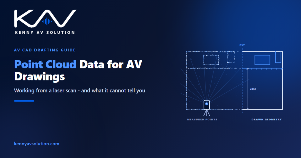
Point cloud AV drawings begin with a file nobody can build from. A laser scan of an existing building is an extraordinarily accurate record of every surface the scanner could see, delivered as tens of millions of coordinates. It is not a drawing, it carries no information about what anything is, and handing one to an installer achieves nothing at all. Somebody still has to draft from it, and the value of the scan depends almost entirely on that step.
What a point cloud is, and what it is not
A terrestrial scanner sits on a tripod, sweeps the space, and records the distance and angle to every surface in line of sight, usually with a colour value from an onboard camera. Move it, scan again, repeat until the area is covered. The output is a cloud of measured points: no walls, no ceilings, no objects, just coordinates.
That distinction matters more than it sounds. A point cloud is measurement, not geometry. It will tell you that a surface exists 2,847mm above finished floor at a given position. It will not tell you that the surface is a suspended ceiling, that the grid is 600mm, or that the tile is demountable. Every one of those facts is an interpretation somebody adds afterwards.
So the useful mental model is not “a 3D model of the building”. It is “a dense, reliable set of measurements that ends the argument about what is actually there”.
When a scan earns its cost
Scanning is not free, and for a single meeting room it is usually overkill. A careful site survey with a laser distance meter answers the same questions for a fraction of the money.
It starts to pay when one or more of these is true:
- The existing drawings are wrong or missing. Historic buildings, repeatedly refitted spaces, anywhere the record set has drifted from the building — the problem described in working with architectural backgrounds.
- The geometry is awkward. Curved walls, raked seating, vaulted ceilings, exposed structure. Anything you cannot honestly describe with a tape measure and a rectangle.
- Access is limited or expensive. A working courtroom, an operating theatre, a plant room you get into once. Capture it thoroughly in the window you have and answer later questions from the data instead of booking another visit.
- Several trades need the same information. Where the structural engineer or the MEP designer is already having the building scanned, the marginal cost of adding your spaces is small. Ask before anyone books a scanner.
- Being wrong is expensive. Custom millwork, a large LED array, anything fabricated off site to your dimensions.
Where none of those apply, a survey is faster and cheaper. The two are not competitors — they answer different questions, and most projects want some of both.
Registration and the coordinate system decide everything
Individual scan positions have to be joined into one coherent cloud, a process called registration. Done well the seams are invisible. Done badly the same wall appears twice a few millimetres apart, and every dimension taken downstream is quietly suspect.
Ask for the registration report. It states the residual error between overlapping scans, and any competent scanning contractor will hand it over without being chased.
More important for drafting: ask what the cloud is referenced to. A scan registered only to itself floats in its own arbitrary space at an arbitrary rotation. A scan tied to the project grid, a survey control point or a shared origin drops straight onto your existing backgrounds and lines up first time. That single decision is the difference between a clean start and a day of manual alignment, and it has to be made before the scanner leaves site. It is the same coordinate discipline that governs any BIM workflow, and it is just as unforgiving.
Density: AV usually needs less than you think
Scan resolution trades detail against file size and time on site. A structural engineer checking slab deflection and an AV designer locating a wall plate do not need the same thing.
For most AV work a moderate density is plenty. You are locating walls, ceilings, structure, existing services and clear routes — features measured in centimetres, not fractions of a millimetre. Where you genuinely want more resolution is in the ceiling void and immediately around any surface something is being fixed to.
Say so up front. Scanning contractors will capture at the highest setting if nobody tells them otherwise, and you inherit a file too large to open on an ordinary workstation, holding detail you were never going to use.
What a scan cannot tell you
This is the part that gets skipped, and it is the part that causes problems on site.
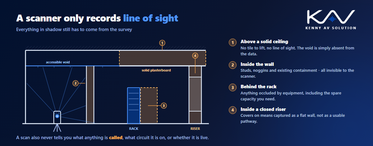
A scanner records line of sight and nothing else. It cannot see inside a wall, above a solid ceiling, behind a rack, inside a riser with the cover on, or through a closed door. It has no idea what anything is called, what circuit it sits on, whether the containment is already full, or whether the existing cabling is live. And it records the building as it was that day, which is not the building at handover.
A scan therefore reduces the survey; it does not replace it. Somebody still has to lift a ceiling tile, open the rack, photograph the labelling and note what is spare — the things a site survey exists to capture. And whatever you scan at the start, you are still producing as-built drawings at the end.
From cloud to AV drawing set
Once the data is registered and referenced, the drafting itself is methodical rather than difficult.
- Section it. A horizontal slice at working height gives you wall positions for the floor plan. A slice above the ceiling gives you the void — structure, ducts, trays, sprinklers — for the reflected ceiling plan.
- Trace what you need, not everything. Modelling every surface is wasted effort. Draw the walls, the ceiling, the structure you are fixing to, and the services you have to avoid.
- Keep the cloud attached as a reference, exactly as you would an architectural background, so anyone can check a dimension against the measurement rather than against your interpretation of it.
- Record what came from the scan and what was assumed. When something is later found to differ, you want to know which category it was in — ordinary revision control hygiene.
Vertical sections cut through a riser or a plant room are particularly worth the effort, both for conduit and riser routing and for rack elevations where the real available height is not what the old drawing claims.
Because the cloud is shared data, it is also a strong coordination artefact: it settles a clash argument with a measurement rather than an opinion, which is the whole point of AV trade coordination.
Formats, file size and what to send your drafter
Scan data arrives in one of two families. Vendor formats come out of the scanner manufacturer’s own software. Open exchange formats — E57 above all, and sometimes LAS, PTS or a structured text export — are readable by nearly everything, and they are what you should ask for in the deliverables list.
A useful handover to whoever is drafting contains the registered cloud in an open format, the registration report, a statement of the coordinate system and units, a plan showing scan positions, and the panoramic images if they exist. The images are often the most valuable part: a 360 view from a known position answers questions the geometry alone cannot.
On size, be realistic. A full-building scan routinely runs to many gigabytes, so agree a transfer method before the job rather than on the day. Decimated or per-area clouds are usually more workable than one enormous file, and most drafting only needs the areas in scope. Whatever you send, the conventions in your AV drawing standards still govern the output — the scan changes where the dimensions come from, not how the drawings look.
Frequently asked questions
Can you produce AV drawings directly from a point cloud? Yes, but not automatically. The cloud is measurement data rather than geometry, so someone has to section it, trace the walls, ceilings, structure and services that matter, and draw the AV set over the top. The scan removes the dimensional uncertainty; it does not remove the drafting.
What file format should I send for scan data? E57 is the safest open exchange format and is readable by almost every CAD and BIM application. LAS, PTS and structured text exports also work. Send the registration report, the coordinate system and units, and the panoramic images alongside it.
Does a laser scan replace an AV site survey? No. A scanner only records what it can see, so it cannot tell you what is above a solid ceiling, inside a wall, behind a rack or inside a closed riser, and it never tells you what anything is called or whether it is live. A scan reduces survey time substantially but does not remove the need for one.
What scan resolution does AV work need? Usually less than structural or MEP work. AV is locating walls, ceilings, structure, services and routes, which is centimetre-level work. Request higher density only in ceiling voids and at surfaces something is being fixed to, and state it before the scan so you do not receive an unmanageably large file.
Why does the coordinate system matter so much? A cloud registered only to itself sits in arbitrary space and has to be aligned to your backgrounds by hand. A cloud tied to the project grid or a survey control point lines up immediately. That decision has to be made before the scanner leaves site, because it cannot be recovered properly afterwards.
Need drawings produced from your scan data?
Kenny AV Solution produces AV drawing sets in AutoCAD for integrators, consultants and contractors worldwide, working from whatever you have — point clouds and scan data, survey notes, marked-up architectural backgrounds or old record drawings. Floor plans and RCPs, sections, rack elevations, conduit and riser routing, signal flow and cable schedules, drawn to your standards and your title block. Send us the E57 and the scope and we will tell you what else we need. See our AV CAD drafting services, grab the free AV CAD Drafting Standards Checklist, or schedule a quick call — we come back with a quote and timeline within one business day. For the underlying documentation standards, AVIXA is the reference worth having on the shelf.